Introduction to Ground Penetrating Radar (GPR)
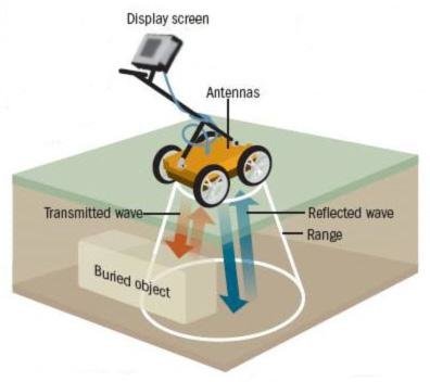
Ground Penetrating Radar (GPR) is a sophisticated and non-invasive geophysical method that employs radar pulses to image the subsurface. This technology has found extensive applications in various domains, including archaeology, geology, and, notably, in the locating of buried utilities. The basic principles of GPR revolve around the transmission of high-frequency radio waves into the ground. When these waves encounter different subsurface structures or materials, they reflect back to the surface, where they are detected by a receiver. The time it takes for the waves to return and their strength help construct an image of the subsurface.
GPR is capable of penetrating a wide range of materials, from rock, soil, and ice to human-made structures like concrete and asphalt. The depth of penetration can vary significantly, typically ranging from a few centimeters to several meters, depending on the frequency of the radar pulses and the material’s properties. Lower frequency waves can penetrate deeper but provide less detail, while higher frequency waves offer more detailed images but shallower penetration.
One of the significant advantages of GPR over traditional methods is its ability to provide a continuous subsurface profile. This continuous imaging capability is particularly beneficial for identifying the location and depth of buried utilities, including non-metallic utilities such as plastic pipes, which are often challenging to detect using other techniques. Moreover, GPR is a non-destructive method, which means it does not disturb the ground or the objects it detects, making it ideal for sensitive sites.
However, GPR does have its limitations. Certain soil types, especially those with high clay content, can cause significant interference, reducing the effectiveness of the radar waves. Additionally, the interpretation of GPR data requires a high level of expertise. Skilled technicians must analyze the radarograms to distinguish between different types of subsurface features and accurately locate utilities.
Despite these limitations, GPR remains a highly valuable tool for subsurface exploration, offering a blend of depth, detail, and non-invasiveness that few other methods can match. Its versatility and effectiveness make it an indispensable technique in the modern toolkit for buried utility locating and other subsurface investigations.
Electromagnetic Locating: Active Locating Method
Electromagnetic locating is a pivotal technique for identifying buried utilities, and active locating is one of its primary methods. This method involves utilizing a transmitter to apply an electromagnetic signal directly onto a utility. The signal is subsequently traced with a receiver, enabling accurate determination of the utility’s location. This process is valuable for various types of utilities, particularly metallic pipes and cables.
The active locating procedure begins with the setup of the transmitter. The transmitter is connected to the utility, either through direct connection or induction. Direct connection involves attaching the transmitter directly to the utility, ensuring a strong and consistent signal. Induction, on the other hand, is used when direct access is not feasible; the transmitter is placed above the ground, and the signal is induced onto the utility below.
Once the transmitter is in place, it emits an electromagnetic signal that travels along the utility. The next step is tracing this signal using a receiver. The receiver is moved along the ground above the suspected path of the utility. It detects the signal and provides feedback on the utility’s location, depth, and orientation. This step-by-step tracing ensures precise mapping of the buried utility.
Active locating is particularly effective for metallic pipes and cables due to their ability to conduct electromagnetic signals efficiently. This method can also be employed in various soil conditions, making it versatile and reliable. Additionally, it is capable of locating multiple utilities simultaneously, streamlining the identification process.
Despite its advantages, active locating does face some challenges. Signal interference from nearby utilities can complicate the tracing process, potentially leading to inaccurate results. Moreover, the requirement for direct access to the utility can be a limitation in certain scenarios. However, with proper planning and execution, these challenges can be mitigated, ensuring the effectiveness of the active locating method.